Azimuth
An azimuth (pronounced /ˈæzɪməθ/ ( listen)) (from Arabic السمت (as‑simt), meaning "direction") is an angular measurement in a spherical coordinate system. The vector from an observer (origin) to a point of interest is projected perpendicularly onto a reference plane; the angle between the projected vector and a reference vector on the reference plane is called the azimuth.
An example of an azimuth is the measurement of the position of a star in the sky. The star is the point of interest, the reference plane is the horizon or the surface of the sea, and the reference vector points to the north. The azimuth is the angle between the north point and the perpendicular projection of the star down onto the horizon.[1]
Azimuth is usually measured in degrees (°)(degrees azimuth). The concept is used in many practical applications including navigation, astronomy, engineering, mapping, mining and artillery.
Contents |
In land navigation, azimuth is usually denoted as alpha,  , and defined as a horizontal angle measured clockwise from a north base line or meridian.[2][3] Azimuth has also been more generally defined as a horizontal angle measured clockwise from any fixed reference plane or easily established base direction line.[4][5][6]
Today, the reference plane for an azimuth in a general navigational context is typically true north, measured as a 0° azimuth, though other angular units (grad, mil) can also be employed. In any event, the azimuth cannot exceed the highest number of units in a circle – for a 360° circle, this is 359 degrees, 59 arcminutes, 59 arcseconds (359° 59' 59").
For example, moving clockwise on a 360° degree circle, a point due east would have an azimuth of 90°, south 180°, and west 270°. However, there are exceptions: some navigation systems use geographic south as the reference plane. Any direction can potentially serve as the plane of reference, as long as it is clearly defined for everyone using that system.
True north-based azimuths
| From North | |||
|---|---|---|---|
| North | 0° or 360° | South | 180° |
| North-Northeast | 22.5° | South-Southwest | 202.5° |
| Northeast | 45° | Southwest | 225° |
| East-Northeast | 67.5° | West-Southwest | 247.5° |
| East | 90° | West | 270° |
| East-Southeast | 112.5° | West-Northwest | 292.5° |
| Southeast | 135° | Northwest | 315° |
| South-Southeast | 157.5° | North-Northwest | 337.5° |
Calculating Azimuth
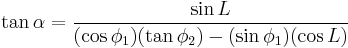
We are standing at latitude  , longitude zero; we want to find the azimuth from our viewpoint to Point 2 at latitude
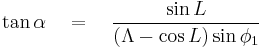
  , longitude L (positive eastward). We can get a fair approximation by assuming the Earth is a sphere, in which case the azimuth is given by
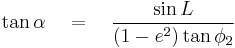
A better approximation assumes the Earth is a slightly-squashed sphere (a spheroid); "azimuth" then has at least two very slightly different meanings. "Normal-section azimuth" is the angle measured at our viewpoint by a theodolite whose axis is perpendicular to the surface of the spheroid; "geodetic azimuth" is the angle between north and the geodesic-- that is, the shortest path on the surface of the spheroid from our viewpoint to Point 2. The difference is usually unmeasurably small; if Point 2 is not more than 100 km away the difference will not exceed 0.03 arc second.
Various websites will calculate geodetic azimuth—e.g. the NGS site. (That site is simpler than it looks at first glance; its default is the GRS80/WGS84 spheroid, which is what most people want.) Formulas for calculating geodetic azimuth are linked in the distance article.
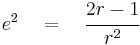
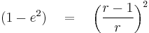
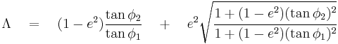
Normal-section azimuth is simpler to calculate; Bomford says Cunningham's formula is exact for any distance. If  is the reciprocal of the flattening for the chosen spheroid (e.g. 298.257223563 for WGS84) then
If = 0 then
Mapping
There are a wide variety of azimuthal map projections. They all have the property that directions (the azimuths) from a central point are preserved. Some navigation systems use south as the reference plane as in the Philippine practice. However, any direction can serve as the plane of reference, as long as it is clearly defined for everyone using that system.
Astronomy
Used in celestial navigation, an azimuth is the direction of a celestial body from the observer.[7] In astronomy, an azimuth is sometimes referred to as a bearing. In modern astronomy azimuth is nearly always measured from the north. In former times, it was common to refer to azimuth from the south, as it was then zero at the same time that the hour angle of a star was zero. This assumes, however, that the star (upper) culminates in the south, which is only true for most stars in the Northern Hemisphere.
Other systems
Right Ascension
If instead of measuring from and along the horizon the angles are measured from and along the celestial equator, the angles are called right ascension if referenced to the Vernal Equinox, or hour angle if referenced to the celestial meridian.
Horizontal coordinate
In the horizontal coordinate system, used in celestial navigation and satellite dish installation, azimuth is one of the two coordinates. The other is altitude, sometimes called elevation above the horizon. See also: Sat finder.
Polar coordinate
In three-dimensional polar coordinate systems, including cylindrical coordinates and spherical coordinates, the azimuth of a point is the angle between the positive x-axis and the projection of the vector onto the xy-plane (the component of the vector in the xy-plane). In cylindrical coordinates, theta,  , is almost universally used to represent the azimuth in mathematical applications, whereas physical applications may denote the azimuth using the symbol phi,
  . Although there are several conventions in spherical coordinates, the azimuth is usually denoted by either theta, , or phi, .
Other uses of the term
The term azimuth is also used in context with military artillery coordination. In artillery laying, an azimuth is defined as the direction of fire.
An azimuth in aerial navigation is defined as the direction of flight, as taken from the location of the aircraft.
In mining operations, an azimuth or meridian angle is any angle measured clockwise from any meridian or horizontal plane of reference.
For magnetic tape drives, azimuth refers to the angle between the tape head(s) and tape.
In sound localization experiments and literature, the azimuth refers to the angle the sound source makes compared to the imaginary straight line that is drawn from within the head through the area between the eyes.
An azimuth thruster in shipbuilding is a propeller that can be rotated horizontally.
See also
- Altitude (astronomy)
- Azimuthal quantum number
- Bearing (navigation)
- Course (navigation)
- Inclination
- Longitude
- Magnetic declination
- Panning (camera)
- Solar azimuth angle
- Sound Localization
- Zenith
Notes
- ^ http://dictionary.reference.com/browse/azimuth
- ^ U.S. Army, Map Reading and Land Navigation, FM 21-26, Headquarters, Dept. of the Army, Washington, D.C. (7 May 1993), ch. 6, p. 2
- ^ U.S. Army, Map Reading and Land Navigation, FM 21-26, Headquarters, Dept. of the Army, Washington, D.C. (28 March 1956), ch. 3, p. 63
- ^ U.S. Army, ch. 6 p. 2
- ^ U.S. Army, Advanced Map and Aerial Photograph Reading, Headquarters, War Department, Washington, D.C. (17 September 1941), pp. 24-25
- ^ U.S. Army, Advanced Map and Aerial Photograph Reading, Headquarters, War Department, Washington, D.C. (23 December 1944), p. 15
- ^ Rutstrum, Carl, The Wilderness Route Finder, University of Minnesota Press (2000), ISBN 0816636613, p. 194
References
- Rutstrum, Carl, The Wilderness Route Finder, University of Minnesota Press (2000), ISBN 0816636613
- U.S. Army, Advanced Map and Aerial Photograph Reading, FM 21-26, Headquarters, War Department, Washington, D.C. (17 September 1941)
- U.S. Army, Advanced Map and Aerial Photograph Reading, FM 21-26, Headquarters, War Department, Washington, D.C. (23 December 1944)
- U.S. Army, Map Reading and Land Navigation, FM 21-26, Headquarters, Dept. of the Army, Washington, D.C. (7 May 1993)
External links
- Chisholm, Hugh, ed (1911). "Azimuth". Encyclopædia Britannica (11th ed.). Cambridge University Press.
- "Azimuth". Collier's New Encyclopedia. 1921.